Natural Hydrogen, Lorrain-Bucke Property, ON
- Option agreement for Lorrain-Bucke, a key property in the Temiskaming hydrogen camp, directly adjacent to Quebec Innovative Materials Corporation (QIMC)’s significant hydrogen discovery.
- Following their drilling success at their St.Bruno-de-Guigues property, QIMC estimates potential hydrogen yields based on the following assumptions: i) that the porosity in the reservoir rock is fully saturated with hydrogen; ii) that the reservoir rock unit extends to a depth of 500 to 1000 meters within a five- square kilometre area.
- These estimates highlight the theoretical resource potential within the fault-associated fracturing porosity of the Lake Timiskaming Graben, with a particular focus on the municipality of St-Bruno-de-Guigues.
- Magnetite is a critical mineral for hydrogen generation and that banded iron formations can become a major source for hydrogen. In addition to ultramafic rock units, extensive areas of iron formations are known to underlie the known areas of reservoir bearing units within the region of the Temiskaming Rift structure thus substantially increasing potential areas of hydrogen accumulation.
Exploration Results:
- The hydrogen anomalies were identified during a recent work program completed by Marc Richer-Lafleche from Quebec City’s Institut National de Recherche Scientifique (INRS), Quebec Innovative Material Corp (QIMC) and Record Resources. What follows are statements quoted or paraphrased from Mr. Richer-Lafleche’s report:
- “During winter work in 2025, a joint scientific team (QIMC, Record Resources, INRS and Timiskaming First Nation) carried out a geochemical survey to measure dissolved hydrogen concentrations in the water of Lake Témiscamingue.”
- “Real anomalies were detected in the lake’s deep waters, and more specifically in the transition zone linked to the winter stratification of the lake’s waters.”
- “The survey was carried out along three sections of Lake Témiscamingue (lines 1, 2 and 3), and more specifically in an orientation perpendicular to the main faults of the Lake Témiscamingue graben. These are particularly evident on the Ontario side of the lake.” (See figures 1 and 2 below).
- “The survey was based on holes drilled in the ice with an ice auger. The holes, spaced at approximately 100m intervals, were located by GPS and the bathymetry measured using sonar.”
- “For hydrogen prospecting in a lake watershed, the results show that the prospecting technique is effective for targeting anomalies and also for detecting the processes of hydrogen emplacement and concentration.”
- “On the Ontario side, Quaternary and recent erosion processes have excavated a large part of this cover, exposing bedrock and certain faults on the Ontario coastline. It is likely that hydrogen outgassing is active on the Ontario side, and more specifically in the trenches of the Lake Témiscamingue graben.”
- “This could explain, among other things, the presence of hydrogen at the thermal interface delineating the different water masses of the lake’s winter stratification. Higher-resolution studies in summer will be needed to clarify the mechanisms responsible for the presence of dissolved hydrogen in the deep waters of the Ontario sector of Lake Témiscamingue.”
Geology:
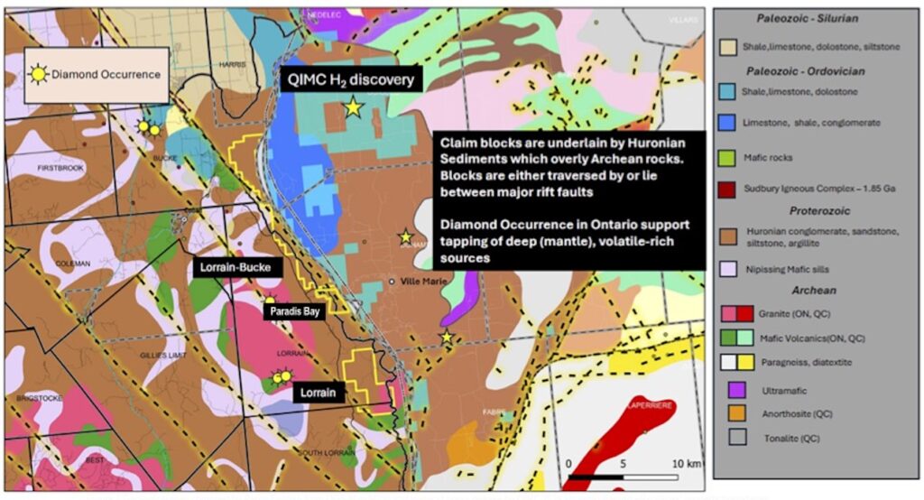
- The Lorrain-Bucke claim blocks are underlain by Huronian Group sedimentary and volcanic formations that unconformably overlie Archean metavolcanic and metasedimentary units of the Superior Province rocks.
- The Huronian Supergoup, in turn, is overlain by a thick succession of Ordovician limestone, dolostone and lesser amount of interbedded sandstone and local conglomerate. This is a geological setup associated with significant natural hydrogen resource potential.
- These blocks are strategically located, between major rift faults in the Lake Temiskaming Graben structure, a tectonic feature recognized for its potential to host deep mantle-derived volatile-rich sources, including hydrogen.
- Claims’ potential is further enhanced by the presence of ultramafic rocks exposed on the northern and eastern portions of the Rift basin in neighboring Quebec. These units exhibit a distinctive magnetic response that extends into Ontario, which suggests the presence of basement ultramafic rocks at the base of the Rift basin.
- A prominent gravity low coincides with a large granitic intrusion mapped in the western Lorrain Township (see QIMC press release December 5, 2024). This gravity low anomaly is shown to extend westward into Lake Temiskaming and potentially marks the location of thick Paleozoic cover, which is a positive indication for deeper natural hydrogen resource potential.
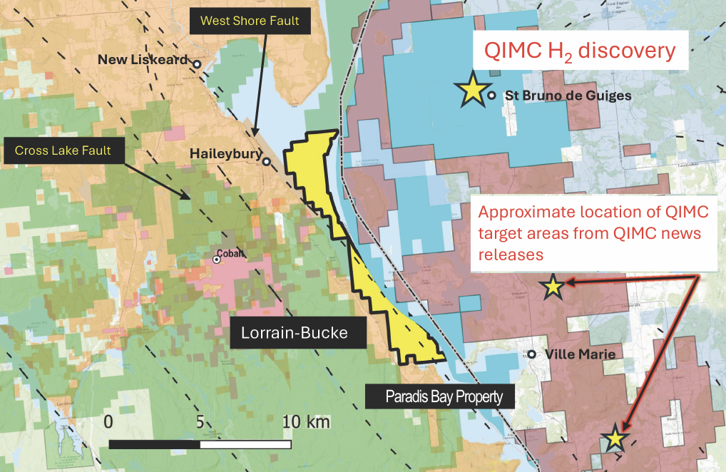
Lorrain Hydrogen Property, ON
• Strategically located between its recently acquired Lorrain-Bucke property and its Paradis Bay hydrogen property.
• Northern boundary of Paradis Bay is contiguous to the Lorrain-Bucke properties completing a chain of properties stretching
30 kilometres along the eastward-dipping Lake Timiskaming West Shore Fault system. See Figure 1 below.
In this area, the sedimentary and volcanic formations dip westward and potentially create structural and hydrological
conditions that can trap the accumulation of gases that contain hydrogen as previously described in press releases (See
Record Resources news releases of January 14, and March 18 2025).
• The string of properties are strategically located, between major rift faults that are part of the Lake Temiskaming Graben
structure, a tectonic feature recognized for its potential to host deep mantle-derived volatile-rich sources, including hydrogen.
Natural Hydrogen, Beauchamp Project, ON
- 100% interest the Beauchamp hydrogen property, consisting of 300 claims situated on a broad northwesterly-trending Lake Timiskaming Rift zone, split by the Cross Lake Fault and extending northward to touch the western margin of the Lake Timiskaming Westshore fault.
- Pivotal western geological extension in Ontario building upon Quebec Innovative Materials Corp. (QIMC)’s landmark Quebec hydrogen discovery.
- Exploration for hydrogen-bearing gas pools have yet to be undertaken on the Beauchamp property. Temiskaming rift faults and earlier crustal faults controlling the emplacement of Nipissing intrusions certainly extend deep into the crust below cover.
- Proterozoic and Paleozoic sediments to tap hydrologic fluid flow in the Archean basement rocks and even magma pools in the upper mantle – conditions very favourable for generating hydrogen gas.
- The presence of broad shallow-dipping low conductive areas at deeper levels may reflect more a highly conducting sedimentary layer but these responses may also indicate a layer containing a trapped hydrogenic gas pool.
- Both faults extend to the southeast. The Lake Timiskaming Westshore (LTW) fault enters Lake Timiskaming at New Liskeard and runs along the west shore of Lake Timiskaming; the Cross lake fault parallels the LTW fault to cut the northwest corner of Record Resources Paradis Bay property and extends into Lake Timiskaming.
- In 2018 Geotech Ltd. undertook on behalf of Meteoric Resources a detailed VTEM Plus and horizontal magnetic Gradiometer geophysical survey of the Beauchamp Property (Project GL180230, OGS assessment report 3649).
- Combined with magnetic horizontal gradient maps it was possible to estimate the depth of the conductive zones and to identify their geometry, orientation, size and the estimated burial depths of the conductors.
- Preliminary calculation shown on the maps have interesting features that can only partially be correlated with known geological observation.
- Short north-south induced magnetic field parallel topographic features have been recognized locally as faults. These short linear features could also indicate hydrologic channels that would produce the same electromagnetic response.
- Exploration activities are expected to commence in 2025, including advanced geophysical analysis and field studies to further evaluate the potential for hydrogen generation and migration within the extension.

Natural Hydrogen, Paradis Bay Property, ON
- 100 percent interest in 27 mineral claims, known as the Paradis Bay property, in the Timiskaming area of Ontario near recent hydrogen discoveries, located along the eastward dipping Lake Timiskaming West Shore Fault system.
- Preliminary examination of the geological, structural and tectonic setting of the Lake Timiskaming claims indicates that the area of the claims may satisfy all parameters required to contain economic native hydrogen reservoirs.
- Discovery of natural hydrogen gas seeps in the Lake Timiskaming area located on the border of Ontario and Quebec.
- Lake Timiskaming is located on the eastern boundary of a rift zone approximately 50 kilometres wide bounded by a series of northwest-southeast trending faults.
- Sedimentary and volcanic formations dip westward and potentially create structural and hydrological conditions that can trap the accumulation of gases that contain hydrogen.
- The Timiskaming Graben Rift System is a long lived pre-existing basement structure associated with crustal extension over the past 700 million years. Down-dropped outlier blocks of Ordovician-Silurian limestone are preserved within the graben at the northern and eastern margin of Lake Timiskaming.
- Seismic reflection data within the area of Lake Timiskaming graben indicate that sedimentary formations even as young as the glacially deposited units are now deformed to form narrow horst and graben structures and a general subsidence over the adjacent area bounded by parallel faults now expressed on land as topographic scraps.
- Being a young active tectonic system reactivated during the Mesozoic Ottawa- St. Lawrence rifting episode, it is probable that temperatures at the base of the Timiskaming graben will be substantial, enough to promote the production of hydrogen at the required rates.
GOLD PROPERTIES, ONTARIO:
Grenfell Gold Property, Kirkland Lake, ON
Joint Venture partnership with Pelangio Exploration Inc.
- The property hosts five distinct gold bearing zones. These zones in order of importance are the No.1 Vein, Sirola Vein, No. 6 Vein, Shea Vein and Shaft Vein.
- 21.7 tons at 0.456 oz per ton gold and 177 tons at 0.70 oz per ton gold, respectively, from two separate bulk samples from the Sirola Vein (surface pit) and No.1 Vein (60-foot level).
- 0.2 oz per ton gold across a 3-foot width for 180 feet of strike length assayed from the No.1 Vein was channel sampled along the drift on the 250-foot level.
- 0.13 oz per ton gold over 10 feet, 2.22 oz per ton gold over 3 feet. and 0.25 oz/ton gold over 5 feet from the The No.6 vein’s three drill holes.
- 0.41 oz per ton gold over 3 feet from a historical drill hole on the Shea Vein.
- 0.24 oz per ton gold over the 60-foot interval from the Shaft Vein, entered at 90-foot level and exited at the 150-level.
Location and History
Located in Grenfell Township approximately 10 km northwest of the Town of Kirkland Lake, Ontario.
Comprised of a series of contiguous mining leases and mining claims covering about 6.7 km2.
The majority of work on the property took place in the 1930’s to early 1940’s when bulk sampling of some high-grade gold veins occurred in conjunction with diamond drilling, shaft sinking and substantial lateral development on two underground levels.
- With renewed interest in the property a series of surface exploration programs were conducted from the early 1980’s to about 2013. More recent exploration work and re-evaluation of historical work has resulted in new zones of gold mineralization and recommendations for further exploration on known historical zones from the 1930-1940 era.
- Gold mineralization was first discovered on the property in the early 1920’s. From the early 1930’s to about 1941, a series of major exploration campaigns were conducted; this work included 265 feet of shaft sinking, over 2000 feet of underground development on two levels, and a bulk sampling program to evaluate two of the vein systems.
- Exploration efforts ceased on the property during World War II. In 1985, a geological report was completed on the property by John Londry, P.Eng. (J. Londry, P.Eng., “Report on the John Sirola Property, Grenfell Township, 1985”).
Kenogami East Gold Property, Kirkland Lake, ON
- 100% owned property, consisting of eleven claim cells known as Kenogami East, in the Kirkland Lake Mining Camp, Ontario.
- Located at the eastern margin of the company’s Grenfell-Four Nations gold property and 8.5 kilometres west of Agnico Eagle’s Macassa Mine. Kenogami East is adjacent to and in some cases overlaps the company’s Grenfell-Four-Nations property.
- Kenogami East and our Grenfell-Four-Nations properties are situated in an area that is highly prospective for significant gold mineralization. There exists widespread occurrences of gold-bearing zones with good grades and widths coupled with the occasional high-grade lodes.
- Gold mineralization closely resembles the gold mineralization on which gold mines were built in the Larder-Victoria Lake and Val d’Or mining camps.
- Identified gold showings in the area have rarely been drilled deeper than 150 metres vertically. It is theorized that better results exist below 150 metres.
- Exploration activities started in 1917 and identified a gold- bearing zone with an average width of 2.5 metres and 91 metre strike length. Reported assays averaged 7.55 grams per tonne in quartz and quartz-pyrite veins. A shaft was sunk to 7.6 metres to mine the vein. No records from this mining activity are available.
- During 1927 to 1928, the shaft was deepened to 164 metres and included production drifts at the two upper levels (the 25 level and 125 level) and exploration drifts at the lower three drifts (the 250 level, 375 level and 500 level drifts).
- During 1933 to 1934, surface mapping, stripping and trenching along with the development of additional underground exploration drifts and drilling were undertaken to trace the extensions of the veining system.
- During 1963 to 1965, 12 drill holes for a total of 2,026 metres were completed on the property to test the down-dip extension of the surface veins.
- Most of the 1960’s drill holes were not correctly located relative to the sampled trenches. More importantly, it was discovered that the east-northeast trending veins were not vertical as previously inferred from surface data but dipped 70-80 degrees to the south. As a consequence, these drill holes stopped short and did not intersect nor test the gold-bearing veins exposed in trenches at the surface.
- The gold-bearing vein zone underlying the property consists of several sub-parallel lenticular grey quartz and less commonly quartz-carbonate veins. These mineralized zones contain assay values averaging 7.5 to 8.6 grams per tonne over widths averaging 2.5 metres.
- As reported by P.T. George (1986), veins discovered to date, contained “significant gold mineralization” averaging 7.6 grams per tonne over average width of 2.5 metres” and it “would be feasible to mine economically” if a “sufficient tonnage of material” were to be established.
- Drilling in 2014, confirmed the that results of earlier campaigns with grades up to various 18.80 grams per tonne.
Amikougami + Otto Gold Exploration Properties, Kirkland Lake, ON:
16 patented claims including 5 mining licences of occupied claims. Amikougami block consists of 7 full and 6 partial patented claims (144 hectares) and the Otto block, which consists of 3 full new claims (48.56 hectares). Combined total for both properties is 192.56 hectares.
Amikougami Gold Exploration Property:
• The Amikougami property lies 4,000 metres north of the Agnico Eagle’s Macassar Mine (2.4 million grams per tonne)
• Deformation zone appears sub-parallel to Kirkland 04-Main Break and associated complex array of secondary splay faults and fracture systems.
• The majority of gold deposits in the Kirkland Lake Gold Camp occur adjacent to the Kirkland 04-Main Break.
• Detailed structural analysis of properties adjacent to Amikougami indicate characteristic structural elements found in the Kirkland 04-Main Break with a southward verging more steeply dipping splay fault of the crustal Kirkland Larder Lake Deformation Zone.
• This may have controlled the evolution of brittle-ductile deformation process and the localization of hydrothermal gold-bearing fluid flow during the evolution of the fault zone creating a possible hosting for economic gold deposits.
• Extended westward, this zone would cross into the Amikougami property, becoming the focus of future exploration activity.
Otto Gold Exploration Property:
• Gold was discovered In 1906 on the north shore of Otto Lake, sparking original gold rush into the Kirkland Lake Gold camp.
• Record Gold’s Otto property is located approximately 2.4 kilometres southwest from the discovery location on Otto Lake and
0.6 kilometres from the west margin of Vigrass Lake.
• Three mines were subsequently developed in the vicinity of the original discovery, located 3.5 kilometres southwest from
Agnico Eagle’s Macassa Mine.
• The original discoveries occurred south of the major crustal deformation zone called the Cadillac-Larder Lake Break, which
occurs less than 1 kilometres north of the Otto property.
• A lesser defined regional fault called the South Break, also associated with carbonate — and with highly deformed, altered,
ultramafic pods — occurs less than 0.4 kilometres north from the property.
• Geological mapping and related geophysical studies in the adjacent properties have located shear zone-bearing quartz veins
and breccia that occasionally carry gold values.
• These structures generally trend in an east-west direction and could possibly extend onto the Otto property.