Record Resources is a Canadian exploration company (TSXV-REC). The company is primarily focused on acquiring and developing its natural hydrogen properties in Ontario. The company also owns gold exploration properties in Ontario. Record Resources is operated by a highly experienced and well connected management team which has access to extraordinary exploration opportunities and technical expertise. The company is also backed by an accomplished group of capital markets professionals.
Natural Hydrogen, Lorrain-Bucke Property, ON
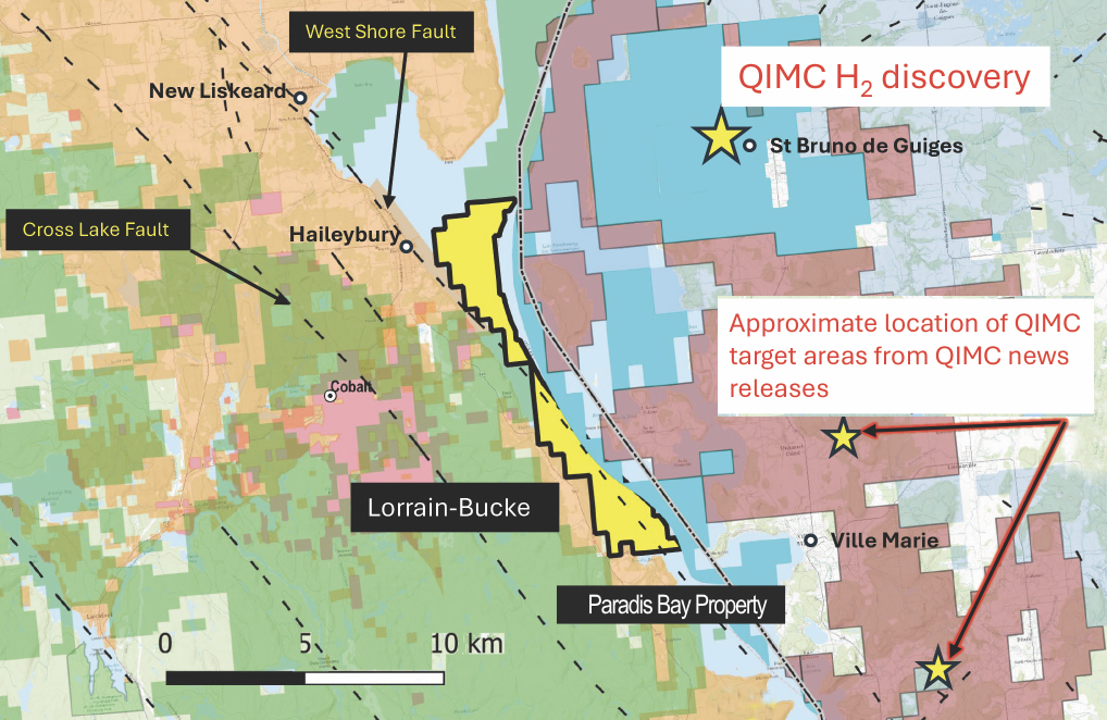
- Option agreement for Lorrain-Bucke, a key property in the Temiskaming hydrogen camp, directly adjacent to Quebec Innovative Materials Corporation (QIMC)’s significant hydrogen discovery.
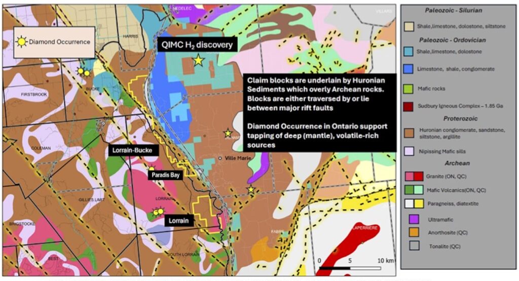
- The Lorrain-Bucke claim blocks are underlain by Huronian Group sedimentary and volcanic formations that unconformably overlie Archean metavolcanic and metasedimentary units of the Superior Province rocks.
- The Huronian Supergoup, in turn, is overlain by a thick succession of Ordovician limestone, dolostone and lesser amount of interbedded sandstone and local conglomerate. This is a geological setup associated with significant natural hydrogen resource potential.
- These blocks are strategically located, between major rift faults in the Lake Temiskaming Graben structure, a tectonic feature recognized for its potential to host deep mantle-derived volatile-rich sources, including hydrogen.
- Claims’ potential is further enhanced by the presence of ultramafic rocks exposed on the northern and eastern portions of the Rift basin in neighboring Quebec. These units exhibit a distinctive magnetic response that extends into Ontario, which suggests the presence of basement ultramafic rocks at the base of the Rift basin.
- A prominent gravity low coincides with a large granitic intrusion mapped in the western Lorrain Township (see QIMC press release December 5, 2024). This gravity low anomaly is shown to extend westward into Lake Temiskaming and potentially marks the location of thick Paleozoic cover, which is a positive indication for deeper natural hydrogen resource potential.
Lorrain Hydrogen Property, ON
• Strategically located between its recently acquired Lorrain-Bucke property and its Paradis Bay hydrogen property.
• Northern boundary of Paradis Bay is contiguous to the Lorrain-Bucke properties completing a chain of properties stretching
30 kilometres along the eastward-dipping Lake Timiskaming West Shore Fault system. See Figure 1 below.
In this area, the sedimentary and volcanic formations dip westward and potentially create structural and hydrological
conditions that can trap the accumulation of gases that contain hydrogen as previously described in press releases (See
Record Resources news releases of January 14, and March 18 2025).
• The string of properties are strategically located, between major rift faults that are part of the Lake Temiskaming Graben
structure, a tectonic feature recognized for its potential to host deep mantle-derived volatile-rich sources, including hydrogen.
Natural Hydrogen, Beauchamp Property, ON
- 100% interest the Beauchamp hydrogen property, consisting of 300 claims situated on a broad northwesterly-trending Lake Timiskaming Rift zone, split by the Cross Lake Fault and extending northward to touch the western margin of the Lake Timiskaming Westshore fault.
- Pivotal western geological extension in Ontario building upon Quebec Innovative Materials Corp. (QIMC)’s landmark Quebec hydrogen discovery.
- Exploration for hydrogen-bearing gas pools have yet to be undertaken on the Beauchamp property. Temiskaming rift faults and earlier crustal faults controlling the emplacement of Nipissing intrusions certainly extend deep into the crust below cover.
- Proterozoic and Paleozoic sediments to tap hydrologic fluid flow in the Archean basement rocks and even magma pools in the upper mantle – conditions very favourable for generating hydrogen gas.
- The presence of broad shallow-dipping low conductive areas at deeper levels may reflect more a highly conducting sedimentary layer but these responses may also indicate a layer containing a trapped hydrogenic gas pool.
- Both faults extend to the southeast. The Lake Timiskaming Westshore (LTW) fault enters Lake Timiskaming at New Liskeard and runs along the west shore of Lake Timiskaming; the Cross lake fault parallels the LTW fault to cut the northwest corner of Record Resources Paradis Bay property and extends into Lake Timiskaming.
- In 2018 Geotech Ltd. undertook on behalf of Meteoric Resources a detailed VTEM Plus and horizontal magnetic Gradiometer geophysical survey of the Beauchamp Property (Project GL180230, OGS assessment report 3649).
- Combined with magnetic horizontal gradient maps it was possible to estimate the depth of the conductive zones and to identify their geometry, orientation, size and the estimated burial depths of the conductors.
- Preliminary calculation shown on the maps have interesting features that can only partially be correlated with known geological observation.
- Short north-south induced magnetic field parallel topographic features have been recognized locally as faults. These short linear features could also indicate hydrologic channels that would produce the same electromagnetic response.
- Exploration activities are expected to commence in 2025, including advanced geophysical analysis and field studies to further evaluate the potential for hydrogen generation and migration within the extension.

Natural Hydrogen, Paradis Bay Project, ON
- 100 percent interest in 27 mineral claims, known as the Paradis Bay property, in the Timiskaming area of Ontario near recent hydrogen discoveries, located along the eastward dipping Lake Timiskaming West Shore Fault system.
- Preliminary examination of the geological, structural and tectonic setting of the Lake Timiskaming claims indicates that the area of the claims may satisfy all parameters required to contain economic native hydrogen reservoirs.
- Discovery of natural hydrogen gas seeps in the Lake Timiskaming area located on the border of Ontario and Quebec.
- Lake Timiskaming is located on the eastern boundary of a rift zone approximately 50 kilometres wide bounded by a series of northwest-southeast trending faults.
- Sedimentary and volcanic formations dip westward and potentially create structural and hydrological conditions that can trap the accumulation of gases that contain hydrogen.
- The Timiskaming Graben Rift System is a long lived pre-existing basement structure associated with crustal extension over the past 700 million years. Down-dropped outlier blocks of Ordovician-Silurian limestone are preserved within the graben at the northern and eastern margin of Lake Timiskaming.
- Seismic reflection data within the area of Lake Timiskaming graben indicate that sedimentary formations even as young as the glacially deposited units are now deformed to form narrow horst and graben structures and a general subsidence over the adjacent area bounded by parallel faults now expressed on land as topographic scraps.
- Being a young active tectonic system reactivated during the Mesozoic Ottawa- St. Lawrence rifting episode, it is probable that temperatures at the base of the Timiskaming graben will be substantial, enough to promote the production of hydrogen at the required rates.
GOLD PROPERTIES:
Grenfell Gold Exploration Property, Kirkland Lake, ON
• Joint Venture partnership with Pelangio Exploration Inc.
• Located in Grenfell Township approximately 10 km northwest of the Town of Kirkland Lake, Ontario.
• Comprised of a series of contiguous mining leases and mining claims covering about 6.7 km2.
• Majority of work took place in the 1930’s to early 1940’s when bulk sampling of some high-grade gold veins occurred in
conjunction with diamond drilling, shaft sinking and substantial lateral development on two underground levels.
Kenogami East Gold Exploration Property, Kirkland Lake, ON
• 100% owned property, consisting of eleven claim cells known as Kenogami East, in the Kirkland Lake Mining Camp, Ontario.
• Located at eastern margin of Grenfell-Four Nations gold property and 8.5 kilometres west of Agnico Eagle’s Macassa Mine.
Kenogami East is adjacent to and in some cases overlaps the company’s Grenfell-Four-Nations property.
•. Kenogami East and Grenfell-Four-Nations properties are situated in an area that is highly prospective for significant gold
mineralization. There exists widespread occurrences of gold-bearing zones with good grades and widths coupled with the
occasional high-grade lodes.
Amikougami + Otto Gold Exploration Property, Kirkland Lake, ON
• 16 patented mining claims including 5 mining licenses of occupied claims. Amikougami block consists of 7 full and 6 partial
patented claims (144 hectares). The Otto block consists of 3 full new claims (48.56 hectares). Combined total for both
properties is 192.56 hectares.
• Amikougami Property is 4000 metres from Agnico Eagle’s Macassa Mine (2.4 million ounces at 22 grams per tonne.
• Amikougami property is adjacent to Agnico Eagle exploration claims (some are shared with Kirkland Lake Gold).